


 |
|
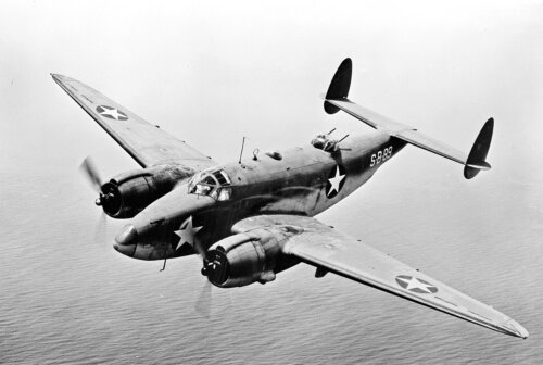
Topographer James McArthur and assistant W.S. Drewry carry photographic equipment to a mountaintop in 1887.
|
In the fall of 1910, an inconspicuous wooden box, measuring about a foot square, arrived in the basement shipping rooms of Department of the Interior, the Ottawa-based federal agency responsible for monitoring the settlement of western Canada. A red label pasted diagonally across one side of the box read: Glass. Handle Carefully. Although the railway manifest provided no other clues as to the contents, experienced clerks in the room knew the box contained several hundred exposed photographic glass negatives–an entire season’s worth of painstaking surveys in one of the most rugged and inhospitable mountain systems in the world.
The negatives had been sent from western Canada to be used in making detailed maps of the Rocky Mountains. When similar boxes first started to arrive in 1886, the use of photography in map-making was considered revolutionary. But after 25 years of experiments and application by Canadian cartographers, the procedure had become so common that Canada had developed an international reputation as a leader in what was widely called “photo-topography.” The shipping manifest estimated the replacement value of the glass negatives at $5,000, but to the map-makers in the building, the negatives were invaluable because without them it would be extremely difficult to make any maps of Canada’s Western Cordillera and its three regions: the Pacific coast, the interior plateau and the interior mountains.
From the moment the Western provinces began to enter Confederation–starting with Manitoba in 1870 and British Columbia in 1871–the federal government envisioned an orderly settlement of the region. Homesteads had to be surveyed, a transportation system built, and a system of law enforcement firmly entrenched before mass immigration from Europe could proceed. Dominion Land Surveyors divided the Prairies into a gigantic checkerboard of more than one and a quarter million homesteads in what would be the world’s largest land survey grid laid down under a single integrated system. It eventually covered over 200 million acres–almost one-tenth of Canada’s entire land mass. Under federal regulations, each of the homesteads had to be marked on the ground and on a map before the land could be opened to settlers.
The Prairies presented few problems for surveyors. The open vistas enabled unobstructed sightings and the near uniform landscape offered few changes that required mapping. But the situation changed drastically once the survey crews reached the foothills of the Rockies. The crews faced a landmass that stretched all the way to the Pacific coast–a landmass that contained a near infinite variety of peaks and valleys in what would prove to be one of the most topographically varied landscapes in North America.
The methods used so successfully on the Prairies–the centuries-old plane-table surveys where distances were measured using a 66-foot-long surveyor’s chain–were tried but proven ineffective on the steep mountain slopes. Rapid surveys based on triangulations and field sketches were also tried, but were equally useless. There was simply too much detail for a surveyor to capture. With their options pretty much eliminated, the surveyors faced a depressing situation: if their surveys did not proceed, the development of a large portion of British Columbia and Alberta would have to be delayed and that could spell serious economic trouble for the fledgling resource industry.
Fortunately, the agency responsible for all federal surveys in the West, the Department of the Interior, had recently hired Édouard-Gaston Deville. A native of France, Deville had just retired from a career on French hydrographic ships in the South Pacific when he arrived on Canada’s doorstep in 1874. Almost immediately, Deville went to work as a surveyor and astronomer in Quebec and within three years was appointed the Quebec government’s inspector of surveys, the province’s top survey position.
However, Deville had more ambitious plans. He wrote and passed exams in high-level survey theory, mathematics, mapping and astronomy and was awarded his certificate as a dominion topographic surveyor. Only three other surveyors before Deville had received the coveted title. Deville soon joined the Department of the Interior in Ottawa and began work on the Prairie homestead surveys, at which he apparently excelled, because in 1881 the minister appointed him inspector of federal surveys. In 1885–the year the Canadian Pacific Railway was completed–he was named Surveyor General of Canada, a position that gave him complete authority over the federal government’s mapping of Western Canada.
Deville thought photography might offer a solution. While a student at the French Naval College at Brest, he heard of the experimental use of photography in the mapping of Paris by Aimé Laussedat, a French army engineer.
Although Deville greatly admired Laussedat’s work, he was also a practical man. He recognized that the science would require extensive re-consideration if it were to be applied to the Canadian situation. The unmanned balloons and kites from which Laussedat suspended his camera over Paris would not be possible in mountainous regions.
Wasting no time, Deville started his own photographic experiments the next field season. He first put his science background to the test and designed a sturdy but light field camera that could be carried for long distances and then re-calibrated once the surveyor arrived at his station. The camera consisted of a rectangular metal case open at one end. The opening contained a series of diaphragms that kept out unwanted light, but permitted the insertion of a four-inch by six-inch glass negative. The other end of the case accepted a mahogany box that held an English-made shutter-less lens.
Deville gave the first camera to James McArthur, one of the federal department’s veteran surveyors. McArthur, as it turned out, was a good choice. Often described as a “quiet and unassuming man” by his peers, he had probably climbed more mountains in the Western Cordillera than any other person. Deville’s instructions to McArthur were straightforward. With his one assistant, McArthur was to take panoramic views from the mountain peaks in Rocky Mountains Park–a new park the federal government established to protect the Banff hot springs.
Unlike Laussedat who worked from vertical photographs, Deville’s method called for oblique or bird’s-eye views of the landscape. With the camera set on a mountain peak and its low-distortion lens carefully levelled and trained on the horizon, the surveyor would take panoramas of the nearby peaks. The precise orientation of each of these views relative to the survey station would be measured using a transit, a surveying instrument used for measuring horizontal angles.
The process would be repeated from another mountain peak so that each feature would be photographed from at least two different angles. Back in the office, the surveyor would plot the camera station on paper, orient each of the photographs relative to the angles recorded by the transit, and draw lines out from the station to each significant feature noted in the photograph. The point at which the lines intersected from two or more stations would be the true position of the feature relative to the camera stations.
Although experimental, McArthur’s initial surveys confirmed Deville’s anticipations. “Instead of the rough and imperfect sketches which such explorations generally furnish,” boasted Deville to the minister of the interior, “we will have, without extra cost and with but little extra office work, complete maps of the country, which if made with the usual methods would absorb very large sums of money.”
McArthur’s surveys were allowed to continue for another six years, and in the end produced a 21-sheet topographical map that covered a 1,300-square-mile section of the Rockies–the entire national park, plus a large area outside the boundaries. Scaled at 1:40,000 or roughly one inch to two thirds of a mile and featuring contour lines at 100-foot intervals, the map was Canada’s first detailed mapping of a mountainous region and was widely hailed a success by professional surveyors across the country.
Photo-topography quickly established itself on the Canadian scene because it eliminated one of the major impediments to surveying in the Western mountains: the short survey season. In higher elevations the survey season was typically limited to a three-month period. Within this narrow window, unstable weather often meant that at best only a few hours a day could be counted on for observations. “We often reached the mountaintop…and remained in mist all day hoping it might clear; only to be obliged to descend without having accomplished anything,” complained McArthur after one particularly long stretch of bad weather.
When the weather did break, they might have only a few minutes to take all their photographs before the clouds obscured the view again. “It often took us from three to eight hours to complete our observations,” explained McArthur, “and many occasions, after shivering with cold all day on the summits, we had to return to camp and await another opportunity.”
During the 1892 field season, McArthur spent only 111 days in the mountains. Out of that total, he lost 48 days to smoke, rain, fog and snow. But he was still able to survey an impressive 475 square miles. In the 1894 field season, the weather was much more favourable. “I made 23 ascents and exposed 275 plates,” wrote McArthur in his report to Deville.
Like his mentor Laussedat, Deville chose a world’s fair–the Chicago Columbian Exposition of 1893–in which to introduce his new mapping technique to the world. A 12-sheet topographic map that covered a 700-square-mile section of the Canadian Rockies was specially made for the exposition. Each sheet was compiled from an average of 16 camera stations that provided the map-makers with up to 120 panoramic views.
The cost of the map worked out to an incredible $7.50 per square mile. “This extremely low figure,” reported Deville, could be attributed to the much smaller portion of time that the topographer “spent in surveying operations…. On the ground he simply collects data and… does not waste any of his time in making measurements. These are left for the winter months, to be attended to in the office.”
Deville later estimated that work requiring eight days in the field using the plane-table method could be carried out by means of photo-topography with only two days of fieldwork and three days of office work. This meant photo-topography was about one third the cost of conventional surveys.
Interest in the map prompted Deville to compile a small pamphlet on the methodology, and two years later, a comprehensive textbook, which, incidently, was circulated among professional surveys nine years before Laussedat published his definitive work on the subject in Europe. Both publications did much to draw the world’s attention to what professional surveyors would later nickname “the Canadian oblique” method of surveying.
By the early 1900s, Deville had attained something of a celebrity status. In 1905, the University of Toronto paid tribute to his “service to the cause of science” when it conferred upon him an honourary Doctor of Laws degree. In 1916, a Royal warrant appointed him a Companion of the Imperial Service Order in recognition of “the sterling services he has rendered to Canada and to the Empire by his researches.”
In 1922, he was nominated to represent Canada at the meetings of the International Union of Geodesy and Geophysics in Rome. His advice was widely sought by a variety of foreign governments that had initiated their own mountain surveys. However, none of their projects would come close to the amount of mapping Canada had undertaken. A copy of his camera was even used in the 1921 mapping of the north slope of Mount Everest.
Surprisingly, the Americans showed little interest in photo-topography even though they shared much of the same topography with Canada. With the exception of some surveys done in the early 1900s in connection with the Alaska-British Columbia boundary, the Americans continued to use plane-table surveys. One of the few American articles on the use of cameras in surveying, which was published more than 30 years after Canada had embraced the technology, was still calling the work “experimental” and “in need of further work.”
At the outbreak of World W ar I, Deville could point to a dozen survey parties working their cameras through the Western Cordillera. As well, in addition to his own department, he could list other Canadian agencies that had fully adopted the technology, including The Geological Survey of Canada, the Geodetic Survey, the International Boundary Commission, and the British Columbia Department of Lands and Works.
Deville died in Ottawa in September 1924, but before his passing Canadian surveyors had used photo-topography to map an incredible 52,000 square miles–an area roughly the equivalent to half the size of the United Kingdom. By comparison, camera surveys in the United States had contributed only 12,400 square miles of new mapping.
When reliable, fixed-wing aircraft came into mass production, Canadian surveyors were quick to realize that aircraft could be used to acquire aerial perspectives similar to those that had been collected from mountain peaks. The main difference of course being that the airplane was more versatile. It allowed them to move away from the mountain ranges, and for the first time, acquire oblique aerial views of other parts of the country.
The new technology was invaluable in areas where differences in elevation were minimal, such as the Canadian Shield and the boreal forest. The hundreds of small lakes that dot these regions were more easily plotted from the air than from the ground.
Despite its versatility, the aircraft did not immediately replace Deville’s camera. On the contrary, the two systems complimented each other for at least 30 years. Deville’s camera was very effective in measuring differences in elevation, but was not very useful in providing details of flat areas. Aerial photography, on the other hand, overcame difficulties with flat terrain, but required Deville’s camera to establish elevations.
The two systems were used throughout the Western Cordillera until the early 1950s when aerial photography could stand on its own as a precise and economical surveying platform for mapping Canada’s varied landscape.
Advertisement